Shallow Water Reservoir Characterisation in the Modern-Day Environments of the Gironde Estuary and Aquitaine Basin / SW France (FTP02)
Description
This field trip, set in the world-famous Gironde estuary, Arcachon lagoon and oceanic coastline of the Bay of Biscay, focuses on the characterisation of reservoirs formed in modern-day shallow water environments.
Facies analysis of fluvial, aeolian, estuarine, lagoonal, coastal marginal marine and shelf deposits will be performed and linked to reservoir quality (porosity/permeability).
Reservoir sandbody characteristics, heterogeneities and geometries will be a central theme of the course in addition to the application of sequence stratigraphic concepts in order to predict the reservoir distribution at basin scale.
The Gironde estuary is a worldwide reference model for tide-dominated incised valleys. It allows a unique opportunity to observe the reservoirs and seals which develop along a 200 km long dip section, through a basin (from fluvial to shoreface). Field work will focus on fluvial point bars located landward of the limit of tides, then on estuarine heterolithic point bars and lastly on sandy tidal bars deposited in the estuary funnel.
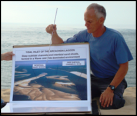
In contrast the Arcachon lagoon is a wave-dominated estuary (Leyre estuary) and the field work in this location will focus on the facies and geometry of sandy tidal channel-fill deposits, as well as on adjacent muddy and sandy tidal flats deposits. The small-scale meandering tidal channels of the inner lagoon will be visited first and then the large scale tidal inlet of the outer lagoon.
The sequence stratigraphic models of the Gironde and Arcachon incised valleys will be compared. Specific processes controlling reservoir geometry will be assessed thanks to new concepts (anchored and sweeping tidal ravinement processes). Preservation potential of the incised valleys on the wave-dominated shelf will also be presented and discussed.
The oceanic coastline of the Bay of Biscay adjacent to these embayments is one of the highest energy wave-dominated oceanic coasts of the world. Beach, shoreface and coastal aeolian dune facies will be presented, utilising trenches, cores and a radar line. The giant wave ravinement surface will be examined, both in trenches and using high resolution seismic lines.
Course Level: Skill
Duration: 4 days
Instructor: Hugues Fenies
Facies analysis of fluvial, aeolian, estuarine, lagoonal, coastal marginal marine and shelf deposits will be performed and linked to reservoir quality (porosity/permeability).
Reservoir sandbody characteristics, heterogeneities and geometries will be a central theme of the course in addition to the application of sequence stratigraphic concepts in order to predict the reservoir distribution at basin scale.
The Gironde estuary is a worldwide reference model for tide-dominated incised valleys. It allows a unique opportunity to observe the reservoirs and seals which develop along a 200 km long dip section, through a basin (from fluvial to shoreface). Field work will focus on fluvial point bars located landward of the limit of tides, then on estuarine heterolithic point bars and lastly on sandy tidal bars deposited in the estuary funnel.
In contrast the Arcachon lagoon is a wave-dominated estuary (Leyre estuary) and the field work in this location will focus on the facies and geometry of sandy tidal channel-fill deposits, as well as on adjacent muddy and sandy tidal flats deposits. The small-scale meandering tidal channels of the inner lagoon will be visited first and then the large scale tidal inlet of the outer lagoon.
The sequence stratigraphic models of the Gironde and Arcachon incised valleys will be compared. Specific processes controlling reservoir geometry will be assessed thanks to new concepts (anchored and sweeping tidal ravinement processes). Preservation potential of the incised valleys on the wave-dominated shelf will also be presented and discussed.
The oceanic coastline of the Bay of Biscay adjacent to these embayments is one of the highest energy wave-dominated oceanic coasts of the world. Beach, shoreface and coastal aeolian dune facies will be presented, utilising trenches, cores and a radar line. The giant wave ravinement surface will be examined, both in trenches and using high resolution seismic lines.
Course Level: Skill
Duration: 4 days
Instructor: Hugues Fenies
Designed for you, if you are...
- An exploration, development or production geoscientist, exploring and developing shallow, marginal reservoirs
- A reservoir engineer with basic geological knowledge, who wishes to link reservoir architecture to production optimisation
Physical Demands
The physical demands of this course are low. Field walks will be slow and field sessions will not last more than a couple of hours. You will be walking in water (water depth: 1 - 2 feet) and on muddy soils. Some transfers are by boat within the channels of the Gironde estuary and the Arcachon lagoon.
How we build your confidence
- Field stops will allow a direct visualisation of the key facies deposited in the various environments of deposition and a direct link to the onsite sedimentary processes
- Geometries and internal heterogeneities of the reservoir geobodies will be described and linked to the processes active within the different depositional environments
- Poster sessions will introduce and summarise the key-points of each field stop. Trenches, numerous cores and high resolution seismic lines will be also utilised to visualise and map reservoir geobodies
- Onsite team work exercises (interpretation of trenches and core descriptions) allow a direct link from sedimentary processes to reservoir quality. Indoor reservoir geology exercises focus on the reconstruction of reservoir architecture with integration of production data (fluids and pressures)
The benefits from attending
By the end of the course, by referencing the modern-day analogues sandbodies of the Aquitaine basin you will feel confident to characterise, map and predict the quality and distribution of reservoirs formed in ancient shallow water environments.And in particular to:
- Assess the key-processes of reservoir genesis in fluvial, aeolian, estuarine, lagoon, marginal marine and shoreface environments and to link these processes to reservoir quality (porosity/permeability) and segmentation
- Assemble detailed facies core descriptions in order to identify the reservoir formed in the environments of deposition along an updip-downdip facies transect (from fluvial to shoreface)
- Evaluate the range of geometries of the reservoir geobodies within each environment and assess the specific processes controlling reservoir geometry
- Reconstruct large-scale reservoir architecture within a sequence stratigraphic framework, with the help of core transects and very high resolution seismic lines
- Integrate production data (fluids, pressures) in order to test reservoir architecture and propose strategies of reservoir optimisation through workovers
- Assess stratigraphic trap potential within incised valley fill
- Construct regional-scale reservoir maps and predict the distribution of reservoir parameters in shallow water environments
Topics
Day 1- The environments of deposition of the Aquitaine basin and the reservoir characterisation tool kit
- Fluvial meandering channels with conglomeratic point bars
- Criteria to recognise the fluvial-estuarine facies transition
- Estuarine meandering channels with heterolithic point bars
Day 2
- Estuary funnel sandy tidal bars (estuarine bay-head delta)
- Internal architecture of the estuarine bay-head delta: reservoirs and internal seals
- Production geology exercise: tidal bars well correlations, with integration of production data
Day 3
- Coastal marine oceanic beaches: backshore, foreshore and swash bars deposits
- Shoreface deposits of the Bay of Biscay
- Sequence stratigraphy of the interfluves of the Gironde incised valley (adjacent to estuary mouth)
- Sequence stratigraphic model and reservoir architecture of the tide-dominated Gironde incised valley
- Exploration geology exercise: well correlations and assessment of stratigraphic trap potential within tide-dominated incised valley fill
Day 4
- Inner lagoon meandering tidal channels and muddy tidal flats
- Outer lagoon tidal inlet channel and sandy tidal flat
- Sequence stratigraphic model and reservoir architecture of the wave-dominated Leyre incised valley (Arcachon lagoon) in comparison with the tide-dominated Gironde incised valley
- Aeolian coastal dune field, with internal architecture of the tallest dune of Europe (Pyla dune)
The course fee includes daily transportation for field visits, local accommodation (5 nights) and full board on course days. For further details please contact training@hoteng.com
Customer Feedback
"On site exercises are very valuable, those images will last." - Geologist at OMV Petrom"Practical session reinforced oral presentations and field observations cemented learning." - Petrophysicist at ADCO
© All rights reserved
HOT Engineering GmbH Tel: +43 3842 43 0 53-0 Fax +43 3842 43 0 53-1 hot@hoteng.com